Spurred by the release of 1.1 billion gallons of coal ash slurry from a surface impoundment at the Tennessee Valley Authority’s Kingston, TN plant, the EPA proposed two regulatory options in 2010 to address potential risks to human health and the environment from the mismanagement of Coal Combustion Residuals (CCR).

The two regulatory options were structured separately, one under RCRA Subtitle C and the other under RCRA Subtitle D. The Subtitle C regulation proposed to categorize CCR as a hazardous waste, and require CCR generators to dispose of it as such. The Subtitle D regulation proposed to establish national standards for landfills and surface impoundments that receive CCR while maintaining them under a solid waste categorization.

In 2015, Coal-Fired Power Plants supplied approximately 33% of U.S. electric power.

The United States possesses more recoverable coal reserves than any other country in the world. Of the U.S. endowment, some of the cleanest and most accessible reserves are found in the Rocky Mountain and Great Plains Region, characterized by subbituminous low-sulfur deposits that lie in thick, near-surface beds, offering substantially greater ease of access than Appalachian coal.

The Powder River Basin in Wyoming and Montana alone contributed over 40% of coal mined in the U.S. in 2011. Rocky Mountain and Great Plains coal deposits, comprised of the Power River Basin deposit, along with similar deposits in Montana, North Dakota, Wyoming, Colorado, and Utah, account for nearly 50% of U.S. coal reserves.

According to the 2015 U.S. Annual Coal Report published by the U.S. Energy Information Administration, surface coal mining operations, located predominantly in the aforementioned region, provided between 26,000 and 37,000 U.S. jobs.

Not only do Rocky Mountain and Great Plains coal reserves include a valuable portion of U.S. natural resources, but they also supply a significant percentage of U.S. energy and numerous jobs. Amidst a rebounding U.S. job market and economy, these resources and job numbers mean a great deal.

Mismanaged Coal Combustion Residuals (CCR) can pose a widespread threat to human health and the environment.

Coal ash, produced from the combustion of coal for power generation, contains elements such as arsenic, cadmium, and mercury.  Although these heavy metals are naturally occurring elements found throughout the earth’s crust, mismanaging high-level concentrations, typically of anthropogenic origin, can easily contaminate groundwater, surface water, and the air.

Arsenic, cadmium, and mercury exposure, even at low levels, has been linked to multiple-organ systemic damage. Additionally, all three are either known or probable human carcinogenic (cancer-causing) agents. Consequently, attentive handling and disposal practices are essential to the mitigation of potential health and environmental risks.

In December of 2014, after eight public hearings and countless public comments, the “Final Rule: Disposal of Coal Combustion Residuals from Electric Utilities” proposed under RCRA Subtitle D, was signed. This new set of standards was entered in to the Federal Register on April 17, 2015.

The Final Rule established technical site requirements for both new and existing CCR landfills and surface impoundments to address the primary risks associated with the storage and disposal of coal combustion residuals. These technical requirements address several components:

  • Reducing the Risk of Catastrophic Failure
  • Protecting Groundwater
  • Operating Criteria
  • Record Keeping, Notification, and Internet Posting
  • Inactive Units
  • State Programs
  • Closure
  • Beneficial Use

Although the more lenient of the two EPA-proposed regulations was used to structure the Final Rule, the technical requirements are stringent, and call for closure of any units that are noncompliant.

To effectively and economically utilize our valuable coal reserves while protecting human health, the environment and our job economy, strategic planning and careful attention to detail is imperative during every step in the process. From well-structured permitting to deliberate design and rigorous monitoring, every detail is vital.

The Final Rule: Disposal of Coal Combustion Residuals from Electric Utilities can be found here:
httpss://www.epa.gov/coalash/coal-ash-rule

A summarized Fact Sheet for the Final Rule on Disposal of Coal Combustion Residuals from Electric Utilities can be found here:
httpss://www.epa.gov/sites/production/files/2014-12/documents/factsheet_ccrfinal_2.pdf

WET’s permitting, environmental, and engineering team has extensive experience dealing with responsible CCR management at large coal-fired power plants; including landfill and surface impoundment permitting, well installation and monitoring, and periodic reporting.

Contact our team to ensure that all projects:

  • Undergo proper evaluation early in the permitting process
  • Are designed efficiently and economically
  • Maintain high environmental standards throughout the duration of the project

As many UAS (Unmanned Aerial System) enthusiasts are well aware, 14 CFR Part 107 (the small UAS rule) went into effect on August 29th.  The much anticipated rule hopefully simplifies things for commercial UAS users.  As part of this rule, UAS operators (now called Remote Pilots) are required to pass a knowledge test administered by the FAA.  In many ways, this knowledge test is similar to the test that manned aircraft student pilots are required to pass in order to receive their pilot certificates.  A few of the knowledge areas included on the test include: The Part 107 rule, airspace classification (this is a big one!), weather, emergency procedures, aeronautical decision making, reading a VFR chart, and airport operations.  Unless you have pre-existing aeronautical knowledge, you definitely want to study up or you may be sweating during the exam!

The FAA’s study guide is a good resource to start your studying.

WET has multiple employees that have passed the Part 107 knowledge exam and hold remote pilot airman certificates with a small UAS rating.  This enables WET to continue to legally provide commercial UAS services to its diverse client base across the Northwest.  Prior to Part 107, WET commercially flew UAS under the rules of an FAA 333 Exemption.  With the implementation of Part 107, the 333 exemptions are still valid and commercial UAS users can legally fly under Part 107 or the 333 exemption.  However, you can’t mix and match requirements from both.

Some noteworthy provisions of the Part 107 rule include: maximum altitude of 400 AGL, operations within controlled airspace require Air Traffic Control permission, and operating a UAS from a moving vehicle is permitted but only in sparsely populated areas (and the operator can’t be driving the vehicle).  Part 107 still requires remote pilots to maintain visual line of sight (VLOS) at all times, however this is a waivable regulation.  So, perhaps Amazon will be using UAS to deliver boxes to our houses sooner than we think!

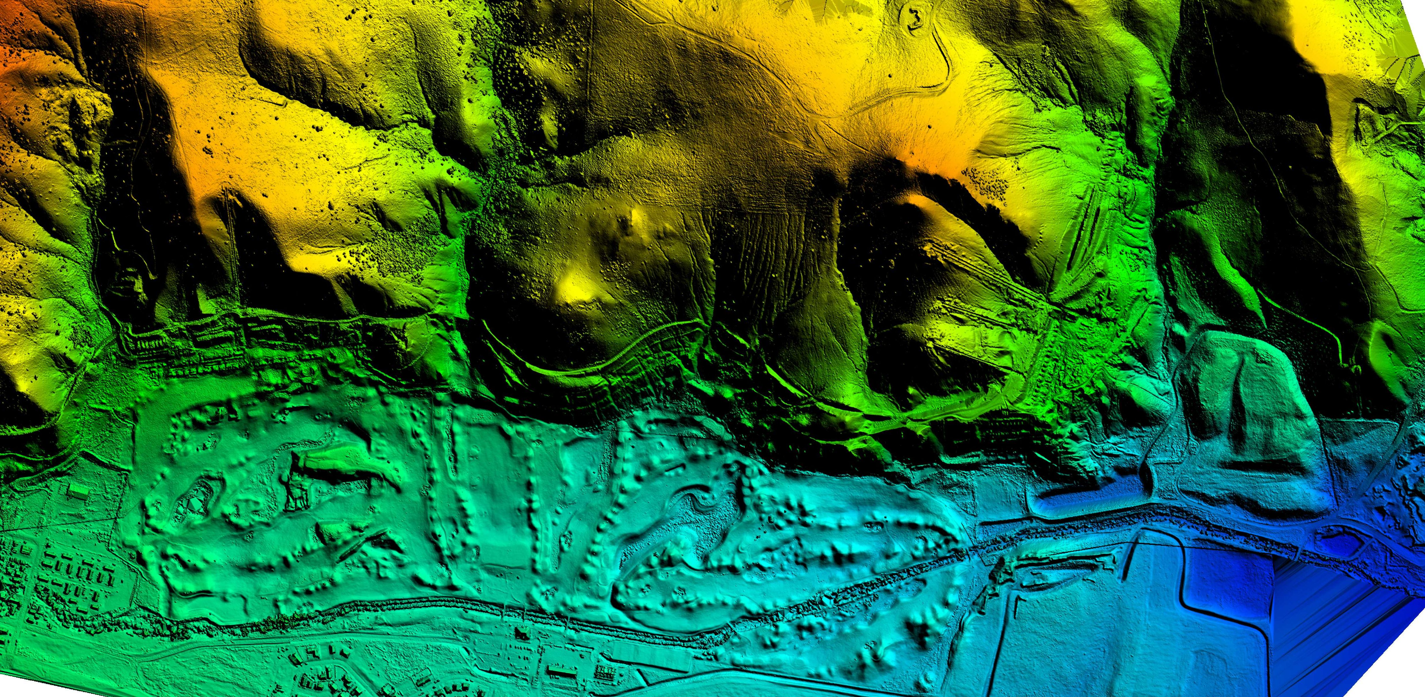
Since entering the UAS market, WET has established itself as a premier provider of UAS services in Montana and the Rocky Mountain region.  WET has completed a variety of projects involving UAS data collection including: stockpile volume surveys, topographic surveys (used for site development, engineering design, environmental permitting, landfill life expectancy, etc.), open pit mine planning surveys, vegetation and weed mapping, and stream temperature mapping.  WET currently owns two Sensefly eBees and a DJI Phantom multi-rotor platform.  WET has access to multiple payloads for the eBees including RGB, NIR (great for vegetation mapping), thermal, and high definition video applications.

Contact WET today to learn more about specific applications and how a UAS survey/mapping project can bring value to your company.

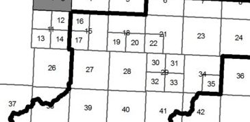
WET contracted with a Montana county to assist them with 911 data collection and mapping.  Recently, the county’s map book needed an update, as their current map book was produced using an extension that is no longer compatible with the latest version of ArcMap.  WET developed a solution to use data driven pages (which is included with ArcMap) to produce a similar project without having to purchase an extension to ArcMap.  We use data driven pages for many different projects in our organization, and ESRI’s online help is a great reference for getting to know how to use the data driven page tools in ArcMap.  You can learn more about building map books with ArcGIS (here).


Here are the basics of making a map book with ArcMap

  1.  Create a new base map with all the layers required for your map book.
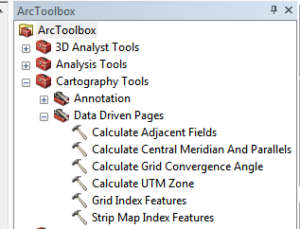
  2.  Choose a suitable layer to use as an index (we used townships for our map book), or use ArcMap’s Data Driven Pages tools from ArcToolbox to build your index.
  3.  There are two options in the toolbox to have ArcMap build an index layer for you:
    1. Grid Index Features (builds a polygon index based on an area)
    2. Strip Map Index Features (builds a polygon index based on a linear feature)
  4.  Once your index is created, use the data driven pages setup button and the data driven pages toolbar to enable data driven pages, define your index layer, name field, sort field, and optional rotation, spatial reference, and page number fields. Also, use the extent tab to choose your margin and scale.
  5.  Now in your layout view, use the Insert > Dynamic Text > to insert Data Driven page attributes into your layout.


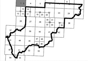
As mentioned earlier, we used section polygons for our index but the issue we had with this approach is that some areas had significantly more detail than others so it was necessary to divide the township polygons into sections to accommodate more details into the map.   Some sections of the county have sparse population where it was sufficient to show the whole township for each page, but other areas needed to be split into 2 or 4 sections to accommodate additional details.  Others have used parcel fabric tools to split the polygons into smaller sections, but the problem this option is that parcel fabric is not included in ArcMap basic.  After some additional research, we discovered a python script for creating a fishnet that appeared to be just what was needed.  After some testing and tweaking of the python script, we were able to divide by polygons!  Here is a copy of the script:


import arcpy, traceback, os, sys, math
from math import radians,sin,cos
from arcpy import env
env.overwriteOutput = True
inFC=arcpy.GetParameterAsText(0)
outFolder=arcpy.GetParameterAsText(1)
rectangle=r’in_memory\rectangle’
tempf=r’c:\junk\many.shp’
def showPyMessage():
arcpy.AddMessage(str(time.ctime()) + ” – ” + message)
def ShapeMake(pGon,angle):
ar=arcpy.Array()
a=radians(angle)
part=pGon.getPart(0)
for p in part:
x,y=p.X,p.Y
xN=cos(a)*x+sin(a)*y
yN=-sin(a)*x+cos(a)*y
pN=arcpy.Point(p.X,p.Y)
ar.add(pN)
pgonRotated=arcpy.Polygon(ar)
return pgonRotatedtry:
arcpy.MinimumBoundingGeometry_management(inFC,rectangle,
“RECTANGLE_BY_WIDTH”, “NONE”, “”, “MBG_FIELDS”)
m,n=0,0
with arcpy.da.SearchCursor(rectangle, (“SHAPE@”,”MBG_Orientation”)) as rows:
for row in rows:
shp,angle = row
onside=ShapeMake(shp,-angle)
extent=onside.extent
origPoint=’%s %s’ %(extent.XMin,extent.YMin)
yPoint=’%s %s’ %(extent.XMin,extent.YMax)
endPoint=’%s %s’ %(extent.XMax,extent.YMax)
arcpy.CreateFishnet_management(tempf, origPoint,yPoint,
“0”, “0”, 5, 5,endPoint,
“NO_LABELS”, “”, “POLYGON”)
arcpy.AddField_management(tempf, “Rotation”, “DOUBLE”)
arcpy.AddField_management(tempf, “Label”, “Text”, 25)
arcpy.AddField_management(tempf, “Grid”, “Text”, 5)
m+=1
with arcpy.da.UpdateCursor(tempf, [“SHAPE@”,”Rotation”,”Label”,”Grid”]) as rows:
for row in rows:
shp = row[0]
rollBack=ShapeMake(shp,angle)
row[0]=rollBack
row[1]=angle
row[2]=str(m)
m+=1
row[3]=str(n)
rows.updateRow(row)
n+=1
m=1
arcpy.CopyFeatures_management(tempf, ‘%s%sfnet_%s’%(outFolder,os.sep,str(n).zfill(4)))
except:
message = “\n*** PYTHON ERRORS *** “; showPyMessage()
message = “Python Traceback Info: ” + traceback.format_tb(sys.exc_info()[2])[0]; showPyMessage()
message = “Python Error Info: ” + str(sys.exc_type)+ “: ” + str(sys.exc_value) + “\n”; showPyMessage()


This script is designed to run with a toolbox in ArcMap. To get it to work for you, simply create a toolbox, edit the variables in the script and run!  Here is what our final output looks like.


Now on to printing map books!

To learn more about WET’s 911 mapping capabilities and other GIS services, call Jeff LeProwse at (406) 782-5220 or visit our website at www.waterenvtech.com/services/gis-consulting.