
MULTIPLE GIS PROJECTS FOR BUTTE-SILVER BOW COUNTY
Butte, Montana
WET has developed several custom mapping applications for the City/County of Butte-Silver Bow to map, manage, and maintain existing Superfund source areas and remedial storm water infrastructure. In 2017 an application was developed to manage operation and maintenance activities within the county, this app leverages ESRI’s ArcGIS online and Survey123 applications as well as a Microsoft Access front end database for querying and reporting capabilities. Using ESRI’s Survey123, field crews can generate categorized inspections and record county-wide Operation and Maintenance (O&M) activities. Managers can use ArcGIS Online web maps to view inspection details and O&M activities, view high priority sites, and complete work assignments. All activities are synced with Microsoft Access to efficiently query data, report on infrastructure conditions, and generate status reports and O&M activities. By utilizing ArcGIS Online, ESRI’s Survey123 and custom JSON feeds this application and saves the county hundreds of hours per year in labor, allowing them to instantaneously view Superfund storm water inspection and maintenance activities and meet reporting and data management requirements.
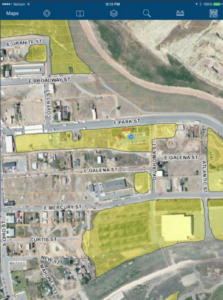
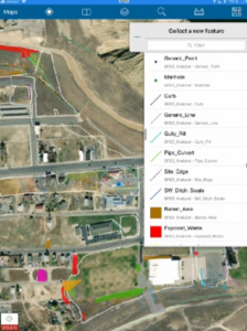
Starting in 2015 WET has been assisting BSB with an application to manage the Butte Reclamation Evaluation System (BRES) data. This application consists of a centralized database to manage, query and report on data collected yearly by BSB employees. The application was initially built using Microsoft InfoPath for data collection but was recently updated to utilize ESRI’s Collector, Survey123 and ArcGIS Online applications. Crews utilize iPads to collect data which is seamlessly updated into an Microsoft Access database to allow project managers to instantly generate queries and reports for data.
WET has been assisting BSB with GIS and mapping projects for the past 10 plus years. Including Sanitary and Storm water infrastructure master plan data collection projects BSB which consisted of large-scale survey, inspection, and documentation of BSB’s storm and sanitary infrastructure an many other mapping projects.
