
MULTIPLE GIS PROJECTS FOR ANACONDA-DEER LODGE COUNTY
Anaconda, Montana
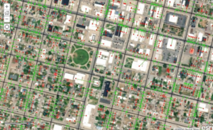
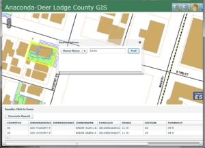
Starting in 2006, WET has assisted Anaconda Deer Lodge County (ADLC) in setting up an ESRI ArcGIS system to manage all the County’s spatial data. This involved assembling data from different sources including paper maps, CAD data, GPS data and existing GIS datasets and organizing the data into a geodatabase to be used for ongoing mapping needs. Since 2015 WET has managed Anaconda-Deer Lodge Counties 911 dataset consisting of approximately 6,300 structures and 2,500 miles of roads. Responsibilities include assigning addresses to new structures, mapping new roads, and updating and maintaining data for emergency services within the county.
WET started assisting the ADLC Road Department in 2017 with digitizing and annually updating their stormwater controls master plan. This involves collaborating with the Road Shop foreman and other Engineers to acquire data of newly added, upgraded, or retired storm water features (i.e., piping, manholes, inlets, culverts, and drain tiles). The data is updated and tracked in a GIS database and used to print large and small format maps for the Road Shop to easily reference.
WET has been working with the ADLC Superfund Coordinator to operate and manage their Superfund Programs for the last 8 years. This entails day to day operation of the Development Permit System and General Utility and Street Opening Permits in coordination with the ADLC Planning Department; including monitoring of the 811-line location notifications, development of work plans for any projects which may encounter mining-related wastes, oversight of soil disturbances, and soil routing using a Field Portable XRF. It also includes the operation of the Community Protective Measures Program which includes community education on Superfund issues and addressing inquiries from the public. A large part of the day-to-day operation includes managing and updating the Superfund Program’s GIS database. Data is acquired from various agencies and entities on a quarterly basis and integrated into the County’s GIS system. This data is used to assist property owners, developers, and contractors while conducting excavation work to protect human health and ensure protective covers and engineered features remain intact. The data is also used to create sampling and remediation maps for property owners to help them better understand work previously conducted or planned for their property.
